Ancient Guntur
The story of Guntur is a river story. The Krishna leaves the Deccan hills, passes the Palnadu country, and opens into a broad, fertile delta before it meets the Bay of Bengal. That meeting of hill, black-cotton soil, and water is why people have lived here for so long.
A nineteenth-century description of the old Guntur / Kistna country still holds for the historic landscape: a fan-shaped coastal delta rising inland into the jungled hills of Palnadu; the Krishna pouring from a narrow gorge into a broadening stream; isolated stone hills rising from the plain. The Krishna travels tens of kilometres through this tract. Palnadu lies on the right bank. Tributaries include the Naguleru, the Chandravanka, and the Gundlakamma.
The valley offered alluvial soils, tanks and ponds, riverine trade, and hill-fort sites inland. People were here long before the first kings we can name.
First people
The official district profile describes this Deccan as an early home of man in India, and states that palaeolithic implements have been found. The named sites behind that sentence are not in the sources used here. The claim is official; the tools are not yet tied, on this site, to a published excavation.
The megalithic centuries are clearer. A necropolis on the left bank of the Nagaleru at Karampudi was first noticed in 1870–71 by J. S. Boswell, then District Collector of Krishna. A 19.2-foot menhir with petroglyphs — circular “head” motifs, domestic animals, a tiger — has been recorded there. A further cluster of menhirs and cist burials stands at Gangalakunta, near Macherla: circular pebble-heaped burials, standing slabs five to eight metres high. Local archaeological comment dates this horizon to about 1000–300 BCE.
Nagarjunakonda, ancient Vijayapuri, has a pre-Buddhist and megalithic background as well as its later city.
Bhattiprolu and king Kuberaka
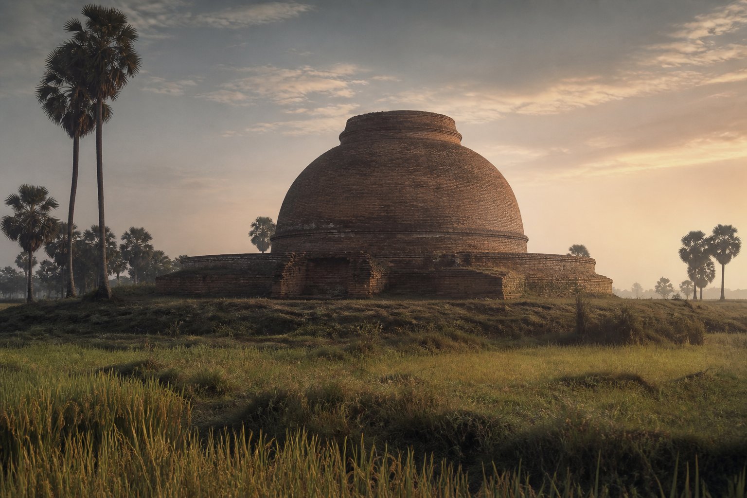
Bhattiprolu, in the Krishna delta of historic Guntur district, is the earliest named kingdom-site in official district memory, and one of the earliest Buddhist relic-stupa sites in South India.
The district remembers a kingdom of Prataliputra — also Pratipalapura — in the fifth century BCE, identified with Bhattiprolu. A Jain literary tradition in the Dharmamrita associates the founding of Pratipalapura with an Ikshvaku prince Yasodhara. That is a literary genealogy, not an excavated foundation date. This site treats the fifth-century kingdom as official and traditional memory.
The earliest writing is later, and it is enough.
The mound — locally Lanja-dibba — was reported by Boswell in 1870. Alexander Rea excavated the ruined brick stupa in 1892 and recovered three inscribed stone relic caskets, each with an inner crystal reliquary, jewels, and relics. An inscription identifies the contents as sharirika-dhatu, bodily relics of the Buddha. The ruined dome was about 132 feet across.
Georg Bühler published ten Bhattiprolu inscriptions in 1894. One records a gosthi — a committee of “sons of the town” — headed by a king named Khubiraka / Kuberaka, who donated a crystal box and a stone box for the relics. Official English pages shorten the name to Kubera and date him around 230 BC. Bühler placed the letters not later than 200 BCE. Akira Shimada dates the caskets about 200–100 BCE and calls them the earliest epigraphic records of Buddhist patronage found in Andhra.
The script is an early Brahmi variety, with several letters formed differently from the northern standard, and a distinctive way of marking vowels. Official and popular histories in Andhra often present Bhattiprolu Brahmi as a progenitor of later Telugu writing. That is a long scholarly conversation, not a single closed proof.
Lead, then, with the caskets, the Buddha-relic inscription, king Kuberaka at the head of a town assembly, and the early letters. Remember Pratipalapura as the ancient name the district still speaks.
Sadas, Satavahanas, Amaravati, Chebrolu
Just upstream of the delta, on the south bank of the Krishna, stood the city remembered as Dhanyakataka — also Dhamñakataka, Dhanakataka; modern Dharanikota beside Amaravati. Beside it rose the Mahachaitya, the Great Stupa of Amaravati, one of the great Buddhist monuments of India.
The stupa may have been founded in the third century BCE, in the time of Asoka, but there is no decisive evidence for an Asokan foundation. The earliest architectural or sculpted remains seem post-Mauryan, from the second century BCE. Official district memory remembers Buddhist seats of learning at Dhanyakataka and Nagarjunakonda, and says Guntur stood foremost in matters of education from the Buddhist epoch.
Nineteenth-century writing often treated the whole sculptural life of Amaravati as “Satavahana.” Later work has given a clearer place to a local coastal house whose names end in -sada. The Sadas may have begun to rule around 20 BCE, perhaps as tributaries of the Mahameghavahana line of Kalinga. Their capital was probably Dhanyakataka; the stupa stood just outside the city. The Velpuru pillar, at the Ramalingesvara temple, names Maha Sada / Maharaja Siri Sada. Excavations at Vaddamanu, east of Amaravati, yielded coins with legends ending in -Sada.
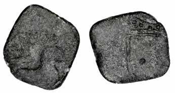
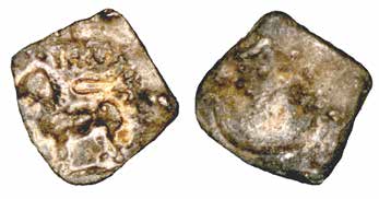
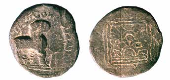
Sada coins: Vaddamanu excavations (BACRI) and British Museum; photographs as published by Shailendra Bhandare, 2016.
The official dynasty list for Guntur begins, after Bhattiprolu, with the Satavahanas. A pillar found while repairing the Bheemeswara temple at Chebrolu was issued by Satavahana king Vijaya in his fifth regnal year, dated by ASI Epigraphy to 207 CE. It is in Sanskrit, in Brahmi characters. A person named Kartika built a prasada and a mandapa, and consecrated images on the southern side of the temple of Bhagavati Saktimatruka at Tambrape — “Tambrape being the ancient name of Chebrolou.” ASI has called this the earliest datable Sanskrit inscription from South India so far.
The same site also yielded a first-century CE Prakrit inscription recording the gift of a cloister mandapa and chaitya — the earliest epigraphic reference to mutts noted in that briefing.
Around 640 CE the Chinese pilgrim Xuanzang described the country of Andhra and, after a long southward journey, To-na-kie-tse-kia — Dhanakataka. The identification with Dharanikota–Amaravati has been standard since the nineteenth century, and it is the one official district memory uses. How long he stayed, and whether he studied specifically at Amaravati or at Bezawada, is later local tradition.
The Ikshvakus of Vijayapuri
When Satavahana power waned in the Krishna valley, the Andhra Ikshvakus made their capital at Vijayapuri — today’s Nagarjunakonda, on the Krishna in the Palnadu country of historic Guntur district.
They ruled the eastern Krishna valley for over a century in the third and fourth centuries CE. Inscriptions have been found at Nagarjunakonda, Jaggayyapeta, Kottampalugu, Gurazala, Rentala, and Uppugunduru. Akira Shimada dates the city about 225–310 CE. Since discovery in 1926, excavations have revealed a citadel and theatre, Buddhist monasteries, and Brahmanical temples. The Nagarjunasagar reservoir later submerged the valley; selected monuments were rebuilt on the island museum.
Coins and inscriptions name four kings: Vashishthiputra Chamtamula, the founder; Mathariputra Virapurushadatta; Vashishthiputra Ehuvala Chamtamula; and Vashishthiputra Rudrapurushadatta. Rudrapurushadatta is attested at Gurazala.
Royal men favoured Vedic and Brahmanical cults; royal women were the great Buddhist donors. Chamtashri, sister of Chamtamula, donated toward a mahachaitya built in the sixth regnal year of her son-in-law Virapurushadatta. A reliquary said by a local inscription to contain a tooth of the Buddha was found in the ruins.
Exact year-by-year chronology is debated, because Ikshvaku inscriptions use regnal years, not a calendar era. Mid-third to early-fourth century CE is the safe public range.
Pallavas, Anandas, Vishnukundins
After the Ikshvakus, several houses touched this district before the Eastern Chalukyas made Vengi their long home.
The early Pallavas are known from Prakrit and Sanskrit charters and from a solitary stone inscription at Manchikallu, in Palnadu taluk. Simhavarman I is dated circa 295–330 CE from that record. The Mayidavolu plates of Yuvamaharaja Sivaskandavarman, issued from Kanchipura, address an official at Dhannakada — Dhanyakataka, modern Amaravati. That is direct Pallava administrative evidence in this tract.
The Ananda gotrins — the district spelling is Anandagothrins — ruled coastal Andhra with capital Kandarapura, in present-day Chejerla mandal, in the later fourth and earlier fifth centuries (a conventional handbook span is 335–425 CE). Only three records and three kings are known: Kandara, founder of Kandarapura; Attivarman, who performed the Hiranyagarbha mahadana; and Damodaravarman, a Buddhist, son of Attivarman. Kandara is said to have won battles against the Pallavas and driven them from the Amaravati region.
The Vishnukundins follow in the standard histories, with a record at Velpur near Sattenapalli. A conventional narrative has them campaign in the Guntur–Tenali–Ongole country and annex Vengi, until Pulakeshin II and his brother Kubja Vishnuvardhana take Vengi, about 616–624 CE.
The sequence this site keeps is the one the stones and the handbooks share: Ikshvaku, then Pallava presence at Manchikallu and Dhanyakataka, then Anandas at Kandarapura, then Vishnukundins, then the Eastern Chalukyas. It does not invent extra kings.
Undavalli
On the right bank of the Krishna, opposite the Amaravati group, a four-storeyed rock-cut temple is cut into the Undavalli hills. It is dedicated to the Hindu trinity, with the principal deity Anantasayi Vishnu. The cutting is about 28 metres long and 15 metres high, excavated from the top down.
On stylistic analysis, the Archaeological Survey of India’s Amaravati Circle dates the earliest phase to the early to mid-seventh century CE. A Telugu label reads “Sri-Utpattipidugu.” Later records of the Reddy chiefs of Kondavidu and of Krishnadevaraya show continued sanctity. Pillars with taranga brackets resemble Pallava work.
Popular and tourism accounts still date the caves to the fourth and fifth centuries CE and to the Vishnukundina dynasty, sometimes as a former Jain or Buddhist monastery later dedicated to Vishnu. Both dates can be told honestly. This site follows ASI for the architectural phase, and names the older popular dating as the long-standing one.
The Eastern Chalukyas, and the first writing of the name
From the seventh century the Krishna–Godavari coastal country — Vengi — was the heartland of the Eastern Chalukyas. Pulakeshin II of Badami appointed his younger brother Kubja Vishnuvardhana viceroy. The viceroyalty became an independent kingdom from 624 CE. Kubja Vishnuvardhana (r. 624–641) took the title Vishamasiddhi.
Guntur’s first securely dated name appears in their copper plates.
In his first regnal year, dated 669 CE, Vishnuvardhana II issued the three-leaf charter now at Pune. The plates name the place Kumturu. That is the earliest known epigraphical mention of the town. The full story of the name — Kumturu, then Gomturu, then Gunturu, then Guntur — is told on The name.
Chebrolu’s Bhimeswara temple is attributed to Eastern Chalukya king Chalukya Bhima in the ninth century. Two-storeyed temples with a tall linga are described as an Eastern Chalukya signature. Peravali plates, from Tenali taluk, record a grant by Vishnuvardhana III of the village of Mavjnthipalli to a Brahman of Peravali.
By the tenth century the Ederu plates of Amma I would call the town Gonturu / Gomturu. The ancient centuries, on this site, close there: a river, a very old people, a relic casket, a great stupa, a Sanskrit pillar at Tambrape, a city in a Palnadu valley, a cave on the Krishna, and a name in copper — Kumturu.